
Accessibility is a very useful tool for bringing together all aspects of the transport/land use system. It provides an integrated measure of the land use system, the distribution of activities (employment, services etc) and the distribution of population. Furthermore, changes in accessibility are a good measure of user benefits from infrastructure improvements, land use changes or policy initiatives.
Accessibility also has strong links to development densities and can be used as a key input into population and employment projections, and optimal city shapes.
TransPosition has used accessibility analysis for a wide range of applications, in many cases making significant contributions to best practice in this area.
TransPosition developed the core technologies underlying Queensland Transport’s LUPTAI project and is using the new TPACS modelling approach to extend accessibility analysis to a range of new applications with improved detail and flexibility.
National Network Analysis
At the national level most planning is done at the corridor level, and there are few tools for analysing the network as a whole. TransPosition has developed one of the first, unified models for the whole country. The model was initially developed for the AUSTROADS Rural Accessibility Project, where it considered travel by road, and used ABS Statistical Local Areas (SLA) as the basic unit for analysis. The model has been used to assess changes to the National Highway, and to consider major new infrastructure projects (such as the Outback Highway, and Pacific Motorway upgrades). The model has also been used for more local analysis, such as the analysis of flood mitigation measures in North Queensland.
TransPosition is in the process of incorporating the TPACS modelling approach into the national model. The initial work is still being done for roads only, but the system will allow for a multi-modal national model to be developed. The key inputs to this are the national rail and air links. The new model treats urban and non urban areas using the same approach. Significantly, this will allow urban projects to be considered and compared using the same tools. It will also allow projects in different cites to be compared on a consistent basis.
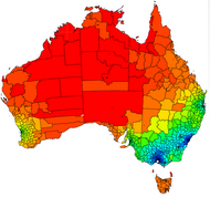
National Accessibility
TransPosition developed one of the first models for the whole of Australia. This map shows overall population accessibility across the country.
National Accessibility
Past projects
TransPosition provides an accessibility analysis as part of their standard model outputs when undertaking a strategic modelling task. Projects where the primary focus has been on Accessibility analysis are shown below and some discussion of our research in this area can be found here.